Posts

Showing posts with the label Remote sensing

Earth observation: bridging the gap to crop-pest systems

Image
The workshop " When Space Meets Agriculture " aimed at promoting a better understanding of the significance and potential of Europe’s space systems (EGNOS/Galileo and Copernicus) for the agricultural sector. While introducing Rural Development Programmes of selected regions and exploring opportunities to set synergies for the development of space applications for the agriculture sector, it will present the main strands of the European Agriculture Policy and more generally link the space community to the agriculture community. Our contribution identified recent and prospective holistic analyses of climate change effects on crop-pest systems in the Mediterranean Basin. The approach used in the analyses involves using physiologically based demographic modeling (PBDM) of crop-pest-natural enemy interactions in the context of a geographic information system (GIS). A major goal is to link the PBDM/GIS technology with increasingly available biophysical datasets from global modeling ...
Remote sensing and invasive species

Image
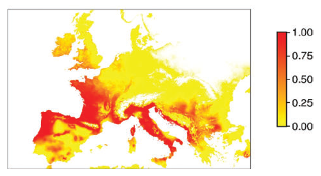
A crucial step in evaluating the impact of invasive species is to map changes in their actual and potential distribution and relative abundance across wide regions over an appropriate time span. While direct and indirect remote sensing approaches have long been used to assess the invasion of plant species, the distribution of invasive animals is mainly based on indirect methods that rely on environmental proxies of conditions suitable for colonization by a particular species. The aim of this article is to review recent efforts in the predictive modelling of the spread of both plant and animal invasive species using remote sensing, and to stimulate debate on the potential use of remote sensing in biological invasion monitoring and forecasting. Rocchini D., Andreo V., Förster M., Garzon-Lopez C.X., Gutierrez A.P., Gillespie T.W., Hauffe H.C., He K.S., Kleinschmit B., Mairota P., Marcantonio M., Metz M., Nagendra H., Pareeth S., Ponti L., Ricotta C., Rizzoli A., Schaab G., Zebisch M., Z...

Course on open source geospatial software

Image
The ENEA Technical Unit for Sustainable Development and Agro-industrial Innovation ( UTAGRI ) organized a course on "Using open source software for remote sensing and GIS applications" sponsored by the GlobalChangeBiology project and taught by Dr. Markus Neteler, head of the GIS and Remote Sensing Unit at Fondazione Edmund Mach (Trento, Italy). The course was held at the ENEA Casaccia Research Center and spanned two days of intensive work (17-18 January 2012). After an introduction to open source GIS, the course moved to practical issues such as software installation, data import and a simple analysis. The remote sensing part started with a review of available data sets, followed by an overview on data import and processing (analysis of time series and classification). Database management was also covered with a focus on SQL, which introduced vector data editing. Last, the GRASS-R interface was illustrated. Even though the course was targeted to ENEA researchers, it attra...

Seminar by M. Neteler, 17 January 2012

Image
The ENEA Technical Unit for Sustainable Development and Agro-industrial Innovation ( UTAGRI ) organized a seminar on "Geographic Free and Open Source Software for remote sensing and GIS: a toolbox for the GlobalChangeBiology project " by Dr. Markus Neteler, head of the GIS and Remote Sensing Unit at Fondazione Edmund Mach (Trento, Italy). The seminar highlighted a wide range of applications implemented via open source software such as remote sensing of biophysical parameters, landscape analysis, environmental modeling, geostatistics, geomorphology, machine learning, management of emerging infectious diseases, and others. Thanks to the GlobalChangeBiology project , ENEA deploys a unique technology in Europe that provides a sound scientific platform for laying out effective response strategies to global change in agriculture. Open source geospatial software is key to achieving a major goal of the GlobalChangeBiology project , namely to link agroecosystem analysis with remote...

Agroecosystems and climate change

Image
In a chapter to appear in the Handbook of Climate Change and Agroecosystems , four approaches used to estimate the potential distribution of native and invasive species in agricultural, natural and medical/veterinary vector/disease systems in the face of climate change are reviewed: (1) time-series observations to document biological responses to changes in climatic variables; (2) remote sensing analysis of data; (3) climate envelope approaches (statistically-based ecological niche models and physiologically-based ecological niche models); (4) physiologically based demographic models. The bases and relative merits of the approaches are discussed. The chapter emphasizes physiologically based demographic models that may be used at the individual, population and regional scales. Such models easily include multiple trophic levels as demonstrated for the olive/olive scale system. The olive/olive-fly system embedded in a geographic information system (GIS) is used to illustrate the utility o...

Project summary

Analytical tools that provide a synthesis of ecological data are increasingly needed to design and maintain sustainable agroecosystems increasingly disrupted by global change in the form of agro-technical inputs, invasive species, and climate change. This is particularly relevant to the Mediterranean Basin, a climate change hot-spot already threatened by local environmental changes including desertification. The project will provide important tools for summarizing, managing, and analyzing ecological data in agricultural systems to address global change effects using grape and olive as model systems. The project will integrate weather driven physiologically based Ecosystem Modelling (EM) and Geographic Information Systems (GIS) to derive a dynamic understanding of complex agricultural systems in the face of global change including climate warming. Multivariate analyses will be used to summarize the main effect of model predictions in a space and time independent way to provide a solid b...