Remote sensing and invasive species
A crucial step in evaluating the impact of invasive species is to map changes in their actual and potential distribution and relative abundance across wide regions over an appropriate time span. While direct and indirect remote sensing approaches have long been used to assess the invasion of plant species, the distribution of invasive animals is mainly based on indirect methods that rely on environmental proxies of conditions suitable for colonization by a particular species. The aim of this article is to review recent efforts in the predictive modelling of the spread of both plant and animal invasive species using remote sensing, and to stimulate debate on the potential use of remote sensing in biological invasion monitoring and forecasting.
Rocchini D., Andreo V., Förster M., Garzon-Lopez C.X., Gutierrez A.P., Gillespie T.W., Hauffe H.C., He K.S., Kleinschmit B., Mairota P., Marcantonio M., Metz M., Nagendra H., Pareeth S., Ponti L., Ricotta C., Rizzoli A., Schaab G., Zebisch M., Zorer R., Neteler M., 2015. Potential of remote sensing to predict species invasions - a modeling perspective. Progress in Physical Geography, http://dx.doi.org/10.1177/0309133315574659
Rocchini D., Andreo V., Förster M., Garzon-Lopez C.X., Gutierrez A.P., Gillespie T.W., Hauffe H.C., He K.S., Kleinschmit B., Mairota P., Marcantonio M., Metz M., Nagendra H., Pareeth S., Ponti L., Ricotta C., Rizzoli A., Schaab G., Zebisch M., Zorer R., Neteler M., 2015. Potential of remote sensing to predict species invasions - a modeling perspective. Progress in Physical Geography, http://dx.doi.org/10.1177/0309133315574659
 |
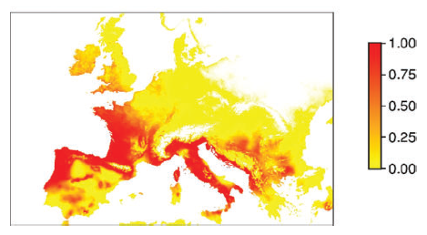
| Suitability of Europe for Asian tiger mosquito Aedes albopictus based on land surface temperatures remotely sensed via MODIS satellites. |


Comments
Post a Comment